


20160727 Valmorel Canirando

xtof_ts
User
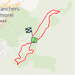

Length
3.8 km

Max alt
1431 m

Uphill gradient
114 m
Km-Effort
5.6 km

Min alt
1312 m

Downhill gradient
181 m
Boucle
No
Creation date :
2016-08-17 00:00:00.0
Updated on :
2016-08-17 00:00:00.0
1h18
Difficulty : Unknown

FREE GPS app for hiking
 SityTrail
IGN / Geographical institutes
SityTrail Plus
The world is yours!
About
Trail Other activity of 3.8 km to be discovered at Auvergne-Rhône-Alpes, Savoy, Les Avanchers-Valmorel. This trail is proposed by xtof_ts.
Description
Canirando près de Valmorel
Positioning
Country:
France
Region :
Auvergne-Rhône-Alpes
Department/Province :
Savoy
Municipality :
Les Avanchers-Valmorel
Location:
Unknown
Start:(Dec)
Start:(UTM)
301800 ; 5038403 (32T) N.
Comments